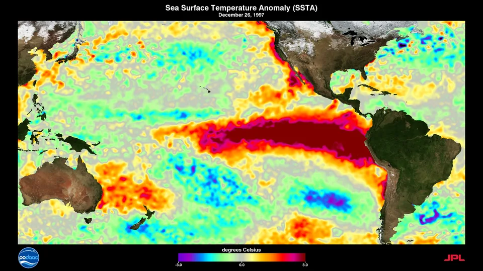
The Pacific Ocean is currently running a fever, and NASA says it's on track to be worse than the one that gave us the legendary 1997-98 El Niño. That event brought fires, crop failures, and coastal flooding to opposite ends of the planet. This one is ramping up faster.
Explain Like I'm 5 · 41-second video

Narrated and captioned. Made by The Dingo Daily from this article.
A 35-Year Paper Trail Says This One Is Big
NASA scientists used satellite data to compare the 2026 El Niño against the strongest events on record, according to a NASA Earth Observatory release published on ScienceDaily. The method is called satellite altimetry, which measures the height of the ocean surface from space. Warm water expands, so a bulge in the sea surface is basically a heat map you can read from orbit.
The record is unusually clean. Successive satellites have flown nearly identical ground tracks with overlapping operating periods, so scientists can line up a 1997 measurement against a 2026 measurement and trust the comparison. NASA put October 13, 1997 next to October 12, 2026. The pictures rhyme.
What an El Niño Actually Is
El Niño shows up every two to seven years, when ocean temperatures in the equatorial Pacific climb above normal. Under usual conditions, trade winds shove warm surface water toward the western Pacific, where it piles up and sits a bit higher than the water in the east.
When those winds weaken, the warm water sloshes back east. That can weaken the winds further, or even reverse them, which lets more warm water slosh east, which weakens the winds again. It's a feedback loop with the whole Pacific as the bathtub. Once it gets going, it reshapes weather far beyond the ocean itself.
The Resemblance to 1997 Is Uncomfortable
The 2026 event intensified far more abruptly than the 1997-98 one did. Despite the different timing, NASA's October measurements show the same basic shape. Sea level is low in the west and high in the east, with a tongue of unusually warm water stretching along the equator all the way to the South American coast.
That matters because 1997-98 was not a quiet year. It delivered substantial rainfall to California and other parts of the southern United States, and NASA notes that similar conditions are possible this coming winter. "Right now, this one is on track to be even bigger," said Josh Willis, project scientist for sea level missions at NASA's Jet Propulsion Laboratory.
What the Last Two Monsters Left Behind
The two big recent El Niños, 1997-98 and 2015-16, both left a mess. Indonesia and the Amazon burned. Southern Africa got drought and crop failures. Southern California got intense rain and coastal flooding.
That's a hell of a résumé for a weather pattern that starts with a slightly warm patch of water. A single ocean temperature anomaly managed to set forests on fire in one hemisphere while drowning beach towns in another. If you wanted a case study in how connected this planet's systems are, you could do worse.
Big Does Not Mean Identical
Here's the part where we are required to be responsible. NASA is not promising a repeat of 1997. The 2015-16 El Niño was also enormous, and it did not play out the same way. "The search for the 'typical' El Niño is very elusive," Willis said. "They're all different in terms of where they land and how their impacts play out."
Where the warmest water pools, and how the atmosphere responds to it, shapes who gets soaked and who gets scorched. The exact impacts of the 2026 event remain uncertain. NASA's own summary says as much. So the honest version is this: it looks enormous, it looks a lot like the nastiest one in living memory, and nobody can yet tell you precisely whose winter it ruins.
Don't Wait for the Weather Report
A powerful El Niño means communities in flood-prone and fire-prone regions have a narrow window to get ready. Southern California in particular has a long, expensive memory of what a wet El Niño winter does to hillsides, drainage, and roads. The warning is arriving months before the rain, which is exactly when preparation is cheapest and most useful.
Whether anyone uses that window is a separate question. Forecasts only matter if someone acts on them.
The Dingo Take
Pay attention to this one. NASA is not an outfit prone to hype, and when its own scientists say this El Niño is tracking to be bigger than 1997, that's a flare shot over the bow.
Here's what makes it maddening. We have 35 years of nearly identical satellites giving us the clearest early warning in the history of weather, and the question that actually decides how bad this gets is whether anyone in a position of power bothers to prepare. Flood control, wildfire readiness, and emergency funding are not glamorous. They are also not optional when the Pacific is running a fever. A government that spends its time gutting science agencies and sneering at forecasts is a strange partner for a planet that keeps handing us advance notice.
The ocean doesn't care about your politics. It will do what the physics tell it to, and the physics say we are getting a monster. The only variable left is how much of the damage we choose to eat.



Comments